The Katun Road

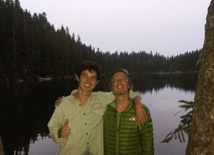
While hiking the PCT I got in touch with a man named Britt Boone who lives in Montenegro. Britt owns a startup travel company in Eastern Europe called Meanderbug (meanderbug.com). After a few months of talking it was decided that I would come for three months and do a work-for-stay. A short two weeks after arriving home from the PCT I set out once again with adventure on the horizon.

Once of the main reasons for my visit was to help create a thru-hike in Montenegro, that follows the scenic Katun Road. This road goes through the north mountains of the country and our goal was to create a hut-to-hut hike. On this type of hike you are able to sleep in a bed and eat real food, but still hike every day.

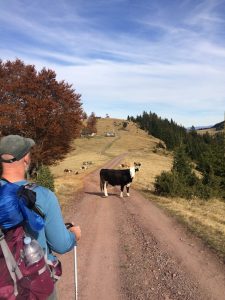
I few days after I arrived we headed out. Never before done, this hike had a lot of unknowns but a shortly after starting we both realized the potential of this hike. The mountains were breathtaking and the cherry on top was the people. Mountain farmers and shepherds were scattered through the area and offered a unique cultural aspect to the hike.


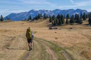
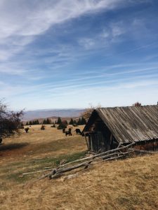
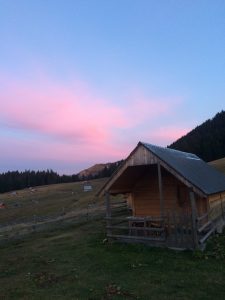
The first day we hiked about 10 km almost exclusively uphill. At this time of year daylight was not on our side so we were not allowed many breaks. Besides talking with a few locals and sadly denying their invitations for coffee, few breaks were taken. Shortly before sunset we arrived at our first Katun. This Katun village was high in the mountains but also in a giant grassy field that was shaped like a bowl, with hills rising up on all sides above the village.

Side note: Katuns are mountain houses generally occupied in the summer months by shepherds so their flocks can graze in the mountains. 

Mountain Katun

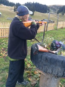
Our Katun was owned by a mountain of a man. Montenegrins are already the third tallest peoples in the world and this man towered above the rest. Since this man spoke no English, Brit was my translator. Almost immediately after arriving he took us to a garden and we dug up fresh mountain potatoes. As we skinned them in the front yard, the other two men in the village brought out their guns and a can shooting tournament was soon in place. Expecting me to not be able to shoot they were all surprised when I knocked down the cans. After Britt told them I was from Texas the all shouted “cowboy!”.

We shared a home cooked traditional Montenegrin meal, and headed to bed in our Katun heated by a small wood burning stove. The next day one of the men from the village offered to hike with us and show us a back-country route that was off of the Katun road. Despite being 70 years old this man lead us from memory through the mountains for half of the day. Only interrupted by a stop from boarder police patrolling the area, we made good time the first half of the day. The second half of the day was different…


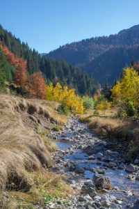
After the old mountain man turned around to go home, we continued confident in our navigation abilities. Ignoring our map, we decided to continue on this back-country route. This was not smart. As we walked we went down almost 3,000 vertical feet, off trail, and ended up in a giant canyon. With nothing else to do we were forced to find a way out. The only way was up so that’s where we went. At an excruciatingly slow pace we climbed, mostly with all fours on the ground, all the way out of the never ending canyon. Unlike the first day, we were not luckily enough to beat the fading sun and shortly after making it out, the sun had completely retreated.

We brought tents and sleeping bags in case we weren’t able to make it one day and I was convinced we would have to use them. With the sun, the temperature also dropped very fast and we still weren’t at our Katun. If we didn’t make it, we would not only have an uncomfortable night, we would let down our hosts. They were expecting us and had spent the day preparing our food. Because of this we hiked on in the dark. Miraculously, Britt got cell service and we found out we were very close. Being night, we had our hosts pick us up and we were inside with warm food only shortly after not expecting to make it at all.

Exhausted from the day’s hike we both knew that this was the conclusion of our trip. With a good start we could get to work on our Katun-Road thru hike and so we arranged a taxi for the next day to take us back to our car.

Although we didn’t finish the hike we were able to recognize the potential this hike could hold and get a idea of the beauty and culture that surrounds it. In the upcoming weeks I will be working with Britt to create this hike. Stay tuned to see how it turns out!

(The blog post I did for Meanderbug is now out!) Check the link below.

Hiking the Katun Road – A Hut to Hut Adventure

Noel Nelson

Goat Rocks

Processed with VSCO with kk1 preset

After a quick goodbye it was back to the trail, having only been in town a few hours. I needed to make up ground and every hour that passed increased my chances of my group getting too far ahead to catch up to. Another reason I was anxious to get back on trail is the next stretch was regarded as one of the best of the whole PCT. The first two days are spent under the shadow of Mt. Adams and the next two are in the Goat Rocks Wilderness. As I rapped around the base of Adams it’s magnificent beauty stopped me at every viewing point. The afternoon I set out I got in 11 miles before dark and set up camp. Stories of one of the famous Washington rain storms coming was circulating on the trail. That night around 11pm the rain begin and as I awoke on the second day, the rain was still going. I tried to pack up as much of my stuff as I could in my tent before getting out but getting wet would be inevitable today. As I hiked, the rain/mist soaked me too the bone and hid the mountain looming close over me. It rained almost the entire day and by the time I got to camp I was still cold and wet. I quickly set up camp and crawled in my sleeping bag. Even though half of my time around Adams wasn’t what I hoped, tomorrow I would enter the Goat Rocks. When I woke on day three, the rainy mist was still there… Preparing for another wet day I started to hike. As the trail climbed I eventually made it above the cloud cover and was given a breathtaking view of Adams with dark clouds at its base. After going over a pass I entered the start of the goat rocks, the land was rich was green grass and alpine streams, all with aggressive rocky mountains looming in the distance. I took a side trail and climbed a close by mountain named Old Snowy. Taking side trips like this are uncommon while thru-hiking but I think it is rather important for the mental aspect to remind yourself that you are out here for fun. Not just to make big miles.
After my side trip I descended back to the pct and to a short section of trail known as “the knifes edge”. Accurately named, this trail walks along a thin mountain edge with massive drops on both sides. Being so high up I was still above the clouds on the knifes edge and the views continued to amaze.
When I reached town the next day I found my group. Sadly Lt Dan was leaving with new people after hiking with the group since the desert. I had to resupply and charge devises so I said goodbye to him and stayed with the others. Unfortunately Lt Dan was the one I was closest with so I felt like an outsider with these people. When I asked to sleep on the floor of their hotel and the said it was too crowded, my suspensions were conformed.
That night I slept on the porch of the hotel and planned to hike with them for only the short foreseeable future.

Processed with VSCO with hb2 preset

Old Friends and New States

The breakfast was everything I dreamed of. After lounging around for the better part of the day in a food coma, I forced myself to leave and get a few more miles in. I finished the last part of Oregon by myself. It was rather uneventful and my mind was on the state to come. Another thing that preoccupied my mind was that my friend Christopher Bitter and his dad and brother were meeting me at the border to backpack with me for a few days. Back home in the summer I pretty much see Chris every day so I was super excited for him to come out to the trail to meet me.

At Cascade Locks the Bitters pulled up in their Uber from the airport. Some negotiations went on between me and Mr Bitter about what gear they should take and then the next morning we headed off. Crossing the Bridge of the Gods, the Oregon/Washington border was a moment I had been thinking about for a long time. From there we hitched to the trial and started the hike.

Brige of the Gods

Right after starting we were hit with a brutal 10 mile climb. I was rather used to these types of climbs but the Bitters were not. Despite their lack of experience with this terrain they all held their own. The first night we dry camped and I showed them a hiker favorite meal. “Hiker bomb” is instant mashed potatoes mixed with ramen soup.

The next day we got in 15 miles ending at Blue Lake. While thru-hiking it is easy to get into a type of funk, where miles are the only thing that matters. You don’t make camp fires or swim in lakes enough and it’s rather sad. With Chris I was able to slow down and truly enjoy the area around me. At blue lake we swam, rock climbed, fished and made a fire. It was a beautiful lake and our night there was one of the best.

Group Picture at Blue Lake

The next day we hiked similar miles and ended at another lake. This time almost all of the camping was taken up by weekenders and we had to struggle to find a spot. We were all a little tired by the time camp got set up so not as many camp activities occurred.


We had originally wanted to finish our trek with a climb of Mt Adams but after learning about how much snow was up there, we decided against it. So without that in the itinerary we had an empty day. We knew we wanted to camp somewhere but our section of trail was ending and it seemed the only place to go was in town.

As soon as we reached the road a trail angel named Gary was there dropping hikers off. We talked with him for a bit and he decided to drive us to a camping spot on a river a few miles away. We all hoped in the couch in the back of his truck and headed down the road. The spot he took us to was super cool and a great way to spend our final night. Additionally the next day was Mr Bitter’s birthday. As it just so happened we did a fifty mile trek for his fiftieth birthday. A great was to celebrate if you ask me.

Couch Hitch

Gary picked us up the next morning and drove us into town where we all devoured some pancakes and french toast. From there I resupplied and the said my goodbyes to the Bitters. Having them was amazing.

Chris Bitter

While we were together my group got a little ahead so hopefully I will be able to catch up before to long. As for now I’m back on my own.

Noel Nelson (PCT mile 2192)

People of the PCT

Left to right: Prince, Hummingbird, Lone Wolf, and Nick

Although the trail possesses immense amounts of natural beauty, it is the people the make the experience as special as it is. With that said, I feel I have neglected this part of my experience in my blog. To fix this, I will introduce you to the people that I have shared the past few months with.

Harry staying warm in short shorts in the snow

From mile 263-788 I backpacked with a guy named Harry. Harry is a 19 year old from Houston Texas. As it just so happens, he will be starting Trinity university in San Antonio this year. Harry runs cross country and ran for a D1 school but didn’t like the grind so he decided to go to trinity. His cross country skills show in his hiking and I had to work hard to keep up with him. The only thing better than his hiking pace are the constant and terrible puns. Sadly, he had to get off trail to train for his upcoming season so in Bishop, we split ways.

Prince is a 20 year old from Denmark. Having never backpacked a day in his life, he decided to do the pct and has been on trail ever since. Additionally, he wins the award for carrying the most candy of anyone on the entire trail. Because of this and his generous spirit, he is a easy person to like and quickly makes friends wherever he goes. I started backpacking with Price at mile 702 and split up with him less then a week ago.

Hummingbird just celebrated her 21 birthday on trail. She is a graduate student at University of Rochester and is studying molecular genetics. Despite meeting much criticism for the idea of attempting the trail, she went anyways which is just one testimony to her drive as an individual. I don’t know if I’ve ever met a more driven person. Even though her hiking pace is slower than mine, she is over 80 miles ahead of me on trail because she keeps going after everyone has stopped to rest.

Lone Wolf is one member of my trail family that I don’t know as well as I would like. The little bit I do know is very intriguing though. With Lana del Ray as her soundtrack, she spent two years living on a sail boat and sailed around the world. You name a place and she’s been. After that she has worked cool jobs at ranches and resorts in exotic places. She is currently with Prince a few days ahead of me.

Nick, Prince, and lone Wolf on the car ride during our flip

I started backpacking with Nick at mile 788 and have been with him ever since. Not only does he have a great taste in music and an impeccable eye for photography, but he finds a way to see the beauty in every situation. When I am tired and slightly angry at the world, Nick’s romantic view of the world rubs off and lightens my mood. Additionally, this 22 year old from Sweden runs a pct blog and is a better writer than I am by miles. So go check out his page. or don’t because it will make me look bad.

People come and go on trail. My time with them is short but their impact on me is great. The trail bonds people in a way normal society fails to. I have only known them a matter of weeks, yet I am closer with them than people I have known for years. They give it character, variety, and meaning. Most importantly, they share in this crazy goal and I feel blessed to call them friends.

Road Trip to Yosemite

View of half dome

Once the decision to flip flop was made, a girl in our group asked her parents to drive up from their home in San Diego and drive us up north. They said yes and as a cherry on top, they allowed us to stay at their cabin for a few days. The cabin is located in the tiny town of Strawberry. With a population of 86, Strawberry is a summer vacation destination, full of camp sites and cabins by the lake. The best part of this town is it’s close proximity to Yosemite National Park.

Shortly after arriving in the cabin we set off to explore the local lake and hiked to a waterfall. The water was freezing but that didn’t stop us from attempting to swim.

Yosemite falls

The rest of the day was spent napping and playing card games.

On day two we woke up early and headed out toward Yosemite. As we drove into the park I felt as though I had entered another world. The giant cliff faces and water falls seemed too grand to be real. Once in the valley we decided on the Yosemite Falls hike. This is a seven mile round trip

On top of yosemite falls

hike with about 5,400 feet of elevation change. The description of the hike said “extremely strenuous” and estimated a travel time of 8 hours. Thanks to our hiker legs my group spent only three hours walking up and down the falls. Even though the actual hiking was quick, on top of the falls we took a lunch/photo shoot/nap break that lasted most of the afternoon.


After reluctantly ending the hike, we loaded back into the car and drove to Glacier Point. From this lookout you could see straight down the valley. Everywhere you looked, giant waterfalls viciously threw water over their edges and “ginormous” cliff faces leaned aggressively over the valley floor. Even with the many tourists the beauty of the valley made me feel very small and alone. I could have spent weeks exploring the valley but by 8 pm we were headed back to the cabin.

After the Yosemite trip it’s back to the trail. We are starting at Truckee (trail mile 1153 and 350 miles ahead of where we left off) today and it’s back to the grind. There will still be snow, but we won’t have the dangerous mountain passes and rivers to cross. I am looking forward to being able to fully enjoy the trail without worry about safety all the time.
-Noel Nelson (pct mile 1153

Entering the High Sierra’s

Sierra’s
Prince Crossing a Bridge

The final stop before the Sierra’s is Kennedy Meadows. From this point on the trail changes drastically. After arriving, I went to pick up the boxes I had shipped to myself and a box my family had shipped. In the four boxes was an ice axe, bear canister, new warmer sleeping bag. The final box had food. After packing everything up, my bag felt like it weighed a thousand pounds. Right before we left, a hiker from Denmark called Price joined Harry and me. The three of us headed out ready for this new and exciting section.

Snow Travel over a Pass

As we walked the trail steadily gained elevation for an entire day, we climbed from 6,000 to 10,000 feet very quickly. Even though the hiking was difficult, I was happily distracted by the beautiful scenery that was around every corner. We celebrated our first day in this section, by making a fire at camp that night (a surprisingly rare thing on the pct). The next two days I climbed up and over two peaks. The first was right around the 10,000 foot mark and the second, closer to 11,000 ft. Each peak had snow on the top but it was easy to walk over and I didn’t even need my snow gear.


After the second pass,

Hitch into Lone Pine

I took a side trail and descended to a park, where my group hitched a ride into the town of Lone Pine. The ride down was the scariest hitch of my life. Not because the people were sketchy, but because I rode in the back of a pickup truck down a mountain road with a major drop off on one side. Luckily I made it down alive and am now preparing for the next section. The next stretch will be one of the hardest. I will climb Mt Whitney and go over the highest pass on the entire trail. Additionally the snow will be a major factor and cut my daily mileage down drastically. Even with all this I am excited for the adventures to come.


-Noel Nelson (pct mile 744)

The Aquaduct

Road Walks

There is a 40 mile stretch of the PCT known for being the hottest and driest part of the whole trail. This section follows the aquaduct the brings water to LA but despite this fact water on the trail is almost nonexistent. Additionally shade is just as rare. As the trail follows the metal pipe it is almost discouraging to look up and see the miles and miles you will have to walk. Unlike the rest of the trail, this part is so flat that you can see the entire never ending section. This makes a 40 mile stretch seem like 400 miles.

Sunset in the Desert

After walking for hours in the blazing sun, we decided it was time to set up camp. It wasn’t until the sun started its retreat from the sky that I realized the beauty of the desert. The sky turned from blue to a deep reddish purple and then to black in a matter of minutes. I thought the best part was over but then the stars came out. Without any light pollution I felt like I could see every star in the galaxy. As I laid down to sleep I could hear the distant cry of coyotes. The day started out rough but in the end I was amazed at how beautiful this place is.

Noel Nelson

Day and Night

  • As I set up camp after a average day on the trail a massive fog rolled in. This isn’t necessarily rare but this fog was thicker than I had ever seen on the PCT. Despite the weather I made my dinner and went to sleep just like any other night. The next morning I awoke, surprised to see that the fog had not only stayed through the night, but that it had grown even more thick. I assumed it would be a wet gloomy day of backpacking, but as I started hiking the trail gained elevation until I had risen above the clouds. It was amazing to look down the mountain and see nothing but clouds below. It made a 7,000 ft peak seem like I was truly high in the sky.

Throughout the day the trail rose and fell, dipping me below the cloud line with every few miles. The stark contrast was amazing and kept things interesting. Below the cloud, the burnt trees surrounded by fog looked extremely ominous but when I would surface above the clouds the sky was as blue as could be. It was like stitching between two different worlds. -Noel Nelson

Boy Scout Mountain

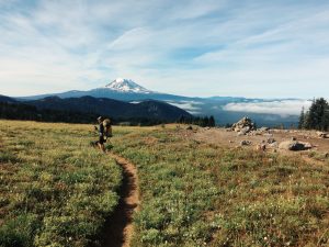
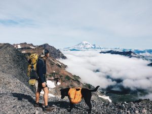
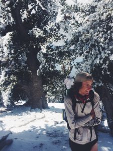
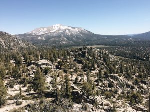
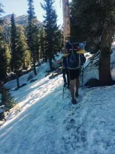
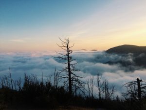
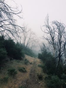
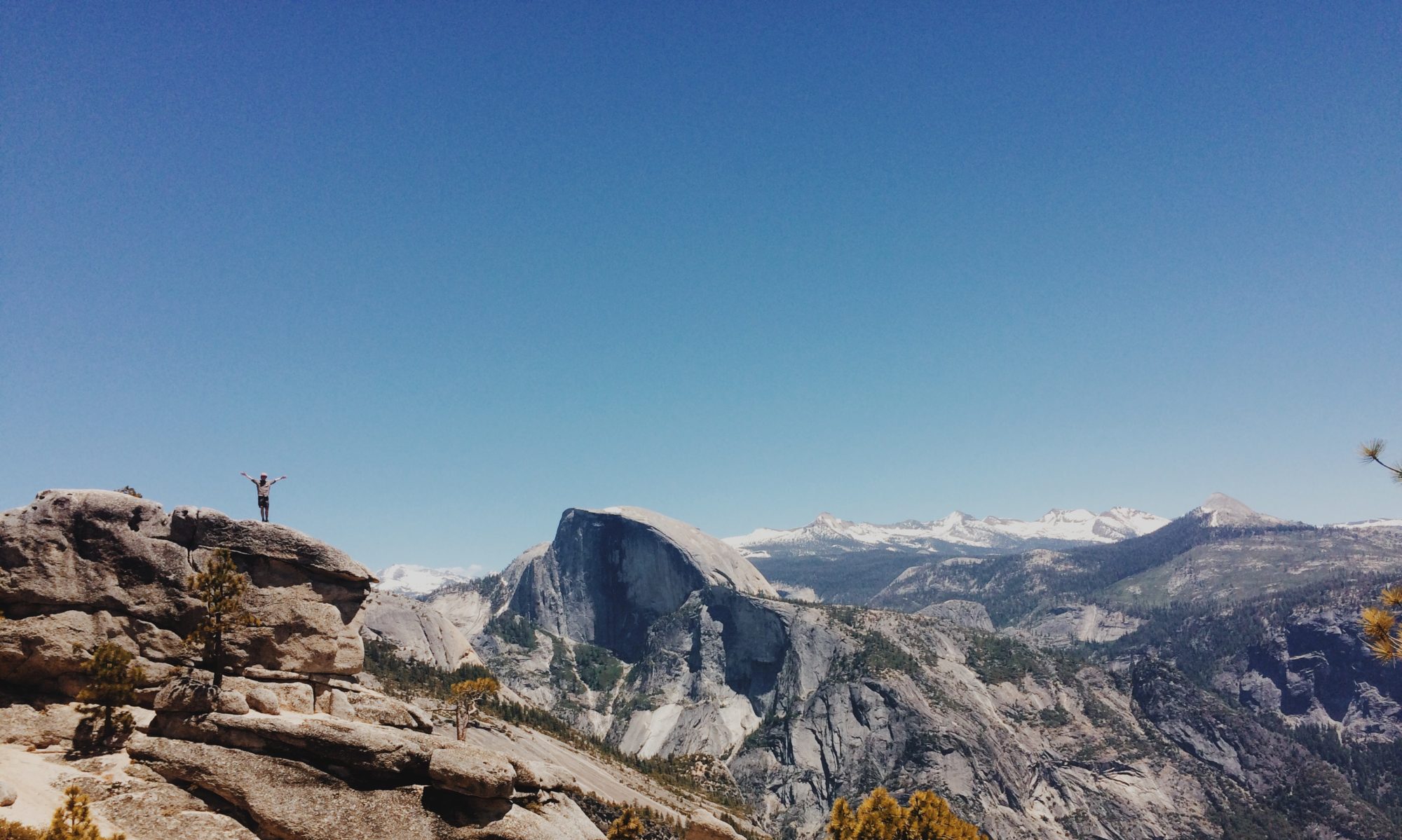
Right outside of the town of Wrightwood lays Mount Baden Powel, a mountain named after the founder of Boy Scouts. While in town a snowstorm passed over, but it left its mark. 
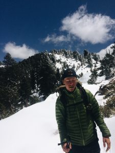
As I ascended the mountain small patches of snow grew into large massive blankets of snow. Miles were spent following nothing but the footprints of those who have gone before me. It took a full twenty mile day to escape the snow, but eventually I was able to set up camp on dry ground. These early encounters with snow are hopefully preparing me for the snow covered Sierras I will go through in a few weeks. -Noel Nelson